Applies to the selected feature.
A region contains a bounding box that describes an area of interest defined by geographic coordinates and altitudes. In addition, a Region contains an LOD (level of detail) extent that defines a validity range of the associated Region in terms of projected screen size.
A Region is said to be "active" when the bounding box is within the user's view and the LOD requirements are met. Objects associated with a Region are drawn only when the Region is active. When the View Refresh Mode is When Region in View, the Link or Icon is loaded only when the Region is active.
For more information, please read Working with Regions  on Google's code web
site.
on Google's code web
site.
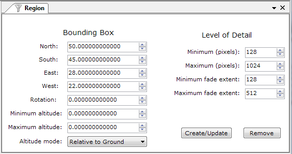
A bounding box that describes an area of interest defined by geographic coordinates and altitudes.
| North: | (required) Specifies the latitude of the north edge of the bounding box, in decimal degrees from 0 to ±90. |
| South: | (required) Specifies the latitude of the south edge of the bounding box, in decimal degrees from 0 to ±90. |
| East: | (required) Specifies the longitude of the east edge of the bounding box, in decimal degrees from 0 to ±180. |
| West: | (required) Specifies the longitude of the west edge of the bounding box, in decimal degrees from 0 to ±180. |
| Rotation: | Specifies a rotation about its center, in degrees. Values can be ±180. The default is 0 (north). Rotations are specified in a counterclockwise direction. |
| Min. Altitude: | Specified in meters (and is affected by the altitude mode specification). |
| Max. Altitude: | Specified in meters (and is affected by the altitude mode specification). |
| Altitude Mode: |
Specifies how the altitude is interpreted. |
Level of Detail (LOD) describes the size of the projected region on
the screen that is required in order for the region to be considered
"active."
Also specifies the size of the pixel ramp used for fading in (from
transparent to opaque) and fading out (from opaque to transparent).
| Minimum (pixels): | Measurement in screen pixels that represents the minimum limit of the visibility range for a given Region. Google Earth calculates the size of the Region when projected onto screen space. It then computes the square root of the Region's area (if, for example, the Region is square and the viewpoint is directly above the Region, and the Region is not tilted, this measurement is equal to the width of the projected Region). If this measurement falls within the limits defined by Minimum (pixels) and Maximum (pixels) (and if the Bounding Box is in view), the Region is active. If this limit is not reached, the associated geometry is considered to be too far from the user's viewpoint to be drawn. |
| Maximum (pixels): | Measurement in screen pixels that represents the maximum limit of the visibility range for a given Region. A value of -1, the default, indicates "active to infinite size". |
| Minimum Fade Extent: | Distance over which the geometry fades, from fully opaque to fully transparent. This ramp value, expressed in screen pixels, is applied at the minimum end of the LOD (visibility) limits. |
| Maximum Fade Extent: | Distance over which the geometry fades, from fully transparent to fully opaque. This ramp value, expressed in screen pixels, is applied at the maximum end of the LOD (visibility) limits. |
| Create/Update: | Creates or resets the bounding box according to the earth client area bounding size. |
| Remove: | Removes the region. |